
NASA JPL Satellite Eyes On the Earth 3D – Gravity Balls and Friends
Posted by pwl on December 10, 2009
Very cool tool from visualizing data from NASA satellites in 3d in a web browser.
What I’m interested in is not just the visualization aspect but the actual data behind the visualizations since as we know from the Climategate confirmations of scientific fraud in climate science visual images can be highly misleading towards the alleged scientists point of view. Raw data please. All manipulations MUST be FULLY documented with the software source code that made the changes and detailed reasons listed for all adjustments.
If we are to raise our knowledge, skills and competence in using the scientific method to study the Earth, Moon, Sol and other relevant systems we must do some basic learning. Hard science requires making use of hard data without cheating and with showing ones data and any adjustments with justifications and open source code for auditing and proper open peer reviews!
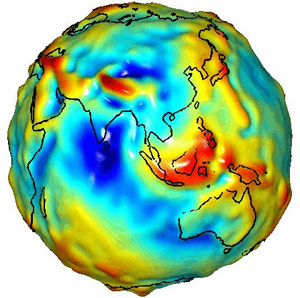
Now let’s see what we can learn from this 3d puppy. My favorite is the GRACE Gravity satellites.
I’ve often wondered what impact the uneven gravity has on the Earth’s climate systems and if the gravity effects are taken into account in the so called climate models. As you can see from the above video the Earth isn’t even an oblate spheroid, it’s a really bumpy place when it comes to gravity. This must impact the weather and thus the climate systems as the atmosphere and water and ice move about.
To use this web based 3d Earth viewer you’ll need to install the plugin. It might mean restarting your browser. I’m using Firefox (on a PC and Mac). I had serious troubles with the “full screen” mode so I’d avoid that like the plague as it required the Ctl-Alt-Del Vulcan Nerve Pinch to get back control of my computer. The view had impolitely changed the screen resolution of my 2560×1600 30″ display to some much lower setting WITHOUT my permission when it switched to full screen! Yikes, when will programmers learn to be polite and ask permission? Also, caution should be used since this plug in might break the flash tools already installed; at least since installing it my WordPress flash tools have been acting weird.
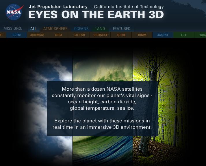
NASA’s “Eyes on the Earth 3D” is back and better than ever before. This online experience now offers new features that allow users to view the latest data beamed back from NASA space satellites – in some cases, less than a few hours old. Developed using a state-of-the-art, browser-based visualization technology, “Eyes on the Earth 3D” displays the location of all of NASA’s 15 currently operating Earth-observing missions in real time.
These missions constantly monitor our planet’s vital signs, such as sea level height, concentration of carbon dioxide in our atmosphere, global temperatures and extent of sea ice in the Arctic, to name but a few. By using the new toolbar on the left of the screen, users can display the latest data maps of ozone, sea level or carbon dioxide. Also new is a video tour hosted by NASA Jet Propulsion Laboratory’s Amber Jenkins, who introduces many of the site’s in-depth features and capabilities. Users can:
* Fly along with a satellite as it sweeps the Earth below in accelerated time.
* Compare the size of each spacecraft to a car or a scientist.
* Blast through a global carbon dioxide map to uncover some of the world’s most populous and polluting cities in the interactive game, “Metropolis.”
A quick overview video to see what “Eyes on the Earth 3D” is all about and some of what you can do with it. Very nice. Excellent science education tool. Kudos to NASA!
Now where is the access to the live raw data? How can I get it streaming into my own model of the Earth?
Now of course there are a lot more (earth observation) satellites in orbit as this image shows. Where do we get the data for those that make it available? Hmmm… anyone care to post links in the comments?

The Nasa “Eyes on the Earth 3D” page also has a “current vital signs” info display. I wonder how that data is calculated. Again it’s not that the data is wrong, but I want to see how it’s calculated and where it comes from and what manipulations have been done and how they justify it’s values though time and what is their science behind it. Simple really, educate me so that I can audit the work!

Watts Up With That has a widget that also shows some of the current vital signs.

Actually they do show a couple more details, which satellite for example, when you mouse over the satellites as they orbit the Earth in the 3D viewer. More details NASA please, more details… all of details! Please.

You can get some extra data mapped onto the Earth 3D model from the “Featured” satellites. One of these are CO2 readings that they claim are about 3 to 4 hours old. Interesting.

No it’s not a horror movie, it’s the Jason 2 satellite and it’s friend the OSTM satellite. The ocean levels satellite views sure look cool. Love to see the raw data though plus their manipulations and their justifications for their manipulations.

Overall I think that lots can be learned by studying the data coming from these satellites, after all that is what they are for. However, NASA clearly has a bias towards the AGW Hypothesis as indicated by the rather large link to the Nasa Global Climate Change web page. Bias doesn’t look good Nasa. PROVE your claims with actual science that is sound and not based upon ANY of the corrupted data from the Climategate alleged scientists Jones, Mann, et. al. or the corrupted temperature data sets involved!
Imagine, if Peter, a sixth grade student, along with his Dad, a biologist, can make significant findings in the public GISS temperature data regarding the existence of the Urban Heat Island Effect (UHIE) and contribute to our understanding of the climate of Earth and Climategate and essentially provide an excellent falsification of the AGW Hypothesis, imagine what you could do with the data from these satellites.
Get out your thinking caps, learn, think and contribute your insightful genius.

isis solar said
isis solar…
NASA JPL Satellite Eyes On the Earth 3D – Gravity Balls and Friends « Paths To Knowledge (dot NET)…
free power energy said
free power energy…
[…]NASA JPL Satellite Eyes On the Earth 3D – Gravity Balls and Friends « Paths To Knowledge (dot NET)[…]…
How To Improve Your Vision naturally said
How To Improve Your Vision naturally…
[…]NASA JPL Satellite Eyes On the Earth 3D – Gravity Balls and Friends « Paths To Knowledge (dot NET)[…]…
Kursi Tamu said
He was the main person behind all success.